Back to the Future: Time Travel and Haplogroup Index
It is 480 CE. It is spring, and a boat of new immigrants rows past the Roman Saxon Shore fort at Burgh Castle. The few guards stationed within the massive flint walls are remnants of the local limitanei—frontier militia who have transitioned from soldiers to hereditary farmers in the seventy years since Rome withdrew its administration.
Rome no longer holds jurisdiction here; its bureaucracy has evaporated. It no longer controls the sea estuary nor decides who may enter or depart. My hypothetical 55th great-grandmother would have faced no imperial barriers to her immigration to Britannia, passing under the gaze of men whose only authority was the land they stood upon. Perhaps she brings with her our mitochondrial DNA Haplogroup H6a1a8 private variant F8693412?

They have crossed the North Sea, having departed from their homeland near the Lower Elbe and the peninsula of Angeln (within present-day Schleswig-Holstein, Northern Germany). We would identify them as the Angles—the specific ethnic group who were to give their name first to East Anglia, and eventually to the kingdom of England.
Their ancestors lived beyond the frontiers of the Western Roman Empire. Her matrilineage may have migrated northwards from Alpine or Carpathian sources, following the course of the Elbe and passing through the Jastorf cultures before finally reaching the maritime peoples of the North Sea coast. There, amongst the salt marshes and estuaries, her kin merged into a distinct Anglian identity.

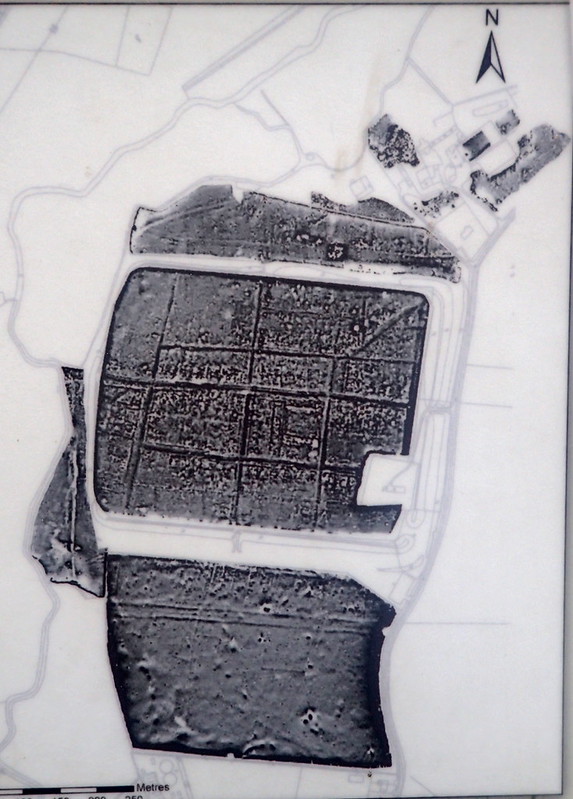
Copyright Source © OpenStreetMap contributors.
The drive to leave their homeland in the Angeln peninsula of present-day Schleswig-Holstein was born of necessity. A deteriorating climate and rising sea levels had turned their traditional coastal farms into waterlogged marshes, creating a desperate environmental push. Conversely, the "pull" of Britain was irresistible; it offered a landscape that was geographically familiar yet significantly more fertile. To these opportunists, the crumbling Roman infrastructure represented a vacuum of power rather than a barrier. They saw a land of established fields and abandoned villas where a new life could be carved out, far from the flooding and tribal volatility of the Germanic north.

The arrival of the Anglian immigrants in the Tas Valley circa 480 CE would have been a moment of profound cultural tension and pragmatic negotiation, played out against the backdrop of the decaying Roman regional capital, Venta Icenorum. By this stage, the town’s orderly grid had largely been reclaimed by the landscape, yet its massive stone walls remained a powerful psychological landmark for the Romano-British locals. These inhabitants—descendants of the Iceni who still viewed themselves as part of a Roman world—likely received the newcomers with a mixture of dread and guarded necessity. Lacking a professional military to defend their farmsteads from northern raiders, the locals may have viewed our fictional 55th great-grandmother’s kin not merely as invaders, but as potential mercenaries or protectors to be settled on the periphery of their territory.
The cultural clash between the two groups would have been immediate and visible. The Britons, likely Christian and still clinging to sub-Roman dress and Latinate customs, would have stood in sharp contrast to the Germanic-speaking Angles, who arrived with their pagan traditions, distinctive cruciform jewelry, and handmade stamped pottery. However, archaeology suggests that this was a period of wary coexistence rather than immediate total conquest. The Angles did not sack the ruins of the town but instead established a "shadow" settlement on the outskirts, utilizing the Roman roads and the river access while maintaining their own traditional timber halls.
Ultimately, the reception in the Tas Valley represented the final, fading heartbeat of Roman authority. The presence of the vast Anglo-Saxon cemetery just outside the walls of Caistor St Edmund indicates that the demographic balance was shifting rapidly. As the Anglian families grew in number and influence, their robust, self-sufficient social structure began to overwhelm the fragmenting Romano-British society. For the locals, the choice was one of gradual integration or retreat, as our ancestor’s people transitioned from being guests on the edge of a ruined city to becoming the new masters of the East Anglian heartland.

Drawing upon the experimental archaeology at West Stow, Suffolk, the primary dwelling our hypothetical ancestors would have constructed upon settling in the Tas Valley was the Sunken-Featured Building, or Grubenhaus. Far from the primitive "pit-houses" once imagined by early historians, these structures were sophisticated domestic units perfectly adapted to the post-Roman landscape. The defining characteristic was a rectangular pit dug into the sandy soil, which served not as a living floor, but as a ventilated air space beneath a suspended timber platform. By supporting the living area above the ground, this design provided crucial insulation and protected the inhabitants from the dampness of the East Anglian earth. Two or three substantial oak posts supported a central ridge pole, upon which rested a steeply pitched roof of water reed or straw thatch that reached nearly to the ground, creating a compact and thermally efficient environment.
Within these thatched dwellings, daily life was dictated by the functional versatility of the space. While they served as primary residences for some, many functioned as specialized craft huts where the naturally humid air trapped beneath the floorboards served a vital purpose. This humidity prevented woollen threads from becoming brittle, making the Sunken-Featured Building the ideal setting for the vertical warp-weighted looms used to produce the tribe's textiles. These buildings were organic and ephemeral; when the timbers eventually succumbed to rot, the community would simply backfill the hollow and erect a new structure nearby, leading to a shifting settlement pattern that contrasted sharply with the fixed masonry of the nearby Roman ruins. For a woman such as our 55th great-grandmother, the construction of these buildings marked the successful transplantation of a continental architectural tradition into the British soil, providing a familiar and self-sufficient home in an uncertain new world.

By 500 CE, the sharp ethnic boundaries of the initial migration had begun to soften into a complex, "hybrid" reality. As Robin Fleming highlights in her work Britain After Rome, the collapse of the Roman state was not just a political failure but a total breakdown of the systems that told people who they were. In this vacuum, identity became something negotiated at the local level, often over the hearth or through the joining of families.
The wedding of a Romano-British bride to a pagan Anglian groom in the Tas Valley would have been a vivid tableau of this social restructuring. For the bride’s father, a man perhaps still clinging to the memory of Roman civitas, the union was likely a pragmatic strategy for survival. By giving his daughter to an Anglian house, he was securing a "blood-bond" with the new military elite who now controlled the flow of grain and the safety of the roads. This was not necessarily a story of romantic integration, but of social re-calibration; the bride’s family provided the local knowledge and agricultural roots, while the groom’s kin provided the protection and the fresh, robust social structure of the comitatus (warband).
Robin Fleming argues that we should look less at "tribes" and more at the re-ordering of daily life. In such a household, the material culture would have become a "creole" of traditions. The bride might have continued to wear a sub-Roman tunic and perhaps a small, hidden lead cross, while her husband displayed the cruciform brooches and great-square-headed fasteners of his Anglian heritage. Their children would grow up in a world where the distinction between "Roman" and "Angle" was increasingly blurred. They might speak a Germanic tongue to their father and a Latinate-influenced Brittonic to their mother, eventually forging the early Old English language.
This "admixing" was the true crucible of the English identity. It was a process of bricolage, where people took the shattered pieces of the Roman past and the raw materials of the Germanic present to build something entirely new. By 500 CE, the Tas Valley was no longer a Roman territory under occupation, nor was it a purely Germanic colony; it had become a frontier zone where the "Roman" was being slowly digested by the "English," creating a society that was tougher, more localized, and ultimately more resilient than the imperial system it replaced.